. Geomorphic
change along southern Parramore Island has been extensive in response to four
major extratropical storms and one significant tropical storm between 1991 and
1994 (<a href=)
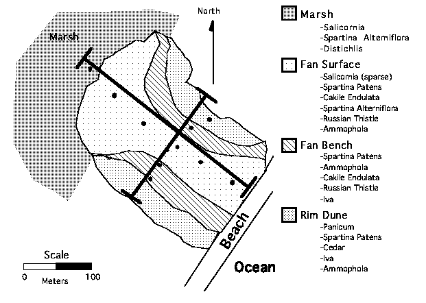 Figure 2. Topography and vegetation facies
map of PAR-3 in July 1994
Figure 2. Topography and vegetation facies
map of PAR-3 in July 1994
R. Craig Kochel, Jon Berntsen and C. Randy Carlson
Department of Geology,
Bucknell University,
Lewisburg, PA 17837
and
VCR-LTER-Station, University of Virginia, Oyster, VA
The establishment and evolution of vegetation on migrating, low-profile barrier islands is greatly affected by the physical hydrogeomorphological processes that regulate island topography and groundwater dynamics. Geomorphological processes such as storm overwash, longshore currents, and eolian activity provide the spatial and temporal framework that account for the destruction and construction of barrier island landforms upon which vegetation can become established. These same processes affect the evolution or succession of vegetative ecosystems because they also regulate the longevity of island landforms through their magnitude and frequency relationships. Fahrig et. al (1993) showed direct correlation of annual and biennial species with areas of high frequency overwash disturbance while perennial species were most common in zones affected infrequently by overwash on Hog Island. Geomorphic processes play a dominant role at scales ranging from macroscopic landscape units such as the creation of patchiness in ecosystems due to wholesale disturbance by overwash to the microscale in subtle variations of microclimate and hydrology over an evolving landscape of beach berms, dunes, and washover channels.
Apart from the physical destruction of plants by overwash processes, fluctuations in the elevation of the water table and variations in groundwater salinity, both spatially and temporally, also appear to have significant impact on the nature and distribution of vegetation patterns on these islands. The dynamics of these two of the major free surfaces, the land surface and the water table, are directly controlled by the hydrogeomorphic processes mentioned above. Understanding the spatial and temporal dynamics of geomorphic change in barrier island environments is essential to understanding the distribution and succession of vegetation. The stability of landforms, their rate of change, the nature of sediment substrates, the shelter provided by landforms to wind and wave interactions, and the access to fresh and saline water govern the composition of island ecosystems. The role of landform development on vegetation is both direct by providing a substrate for establishment and impact by erosion and is indirect through relationships to the island water table and the impact of constructional topography on groundwater salinity. Few studies, however, have followed the morphodynamic evolution of a site through a series of washover events and interim recovery periods over the span of several years.
A group of detailed study sites were established in May 1994 on southern Parramore Island to investigate the long-term dynamics of the relationships between island topography, island hydrology, storm overwash, and vegetation. These sites compliment our network of overwash-monitoring locations along the VCR and were selected to provide a suite of topographically nested overwash areas with fan threshold elevations ranging from 0.8 m to 1.2 m above mean high water. This vertical range affords an opportunity to monitor hydrogeomorphic changes and vegetation at sites with considerable variation in stress due to both overwash frequency and exposure to aeolian activity.
The southern Parramore sites have been instrumented with a network of shallow recording and non-recording wells to monitor groundwater levels and salinity; receive periodic intensive topographic monitoring with laser theodolite surveys, and contain painted sand plugs to monitor surface changes. Hydrogeologic parameters are tracked in conjunction with periodic vegetative mapping in an effort to relate the physical-chemical parameters of the system to vegetative response. Variations in salinity, sedimentology, topography, and vegetation are mapped periodically at all sites using a facies mapping approach, supplemented with selected linear transects and point observations.
Island-wide washover fans and terraces characterize the southern 4 km of Parramore Island. An extensive back-barrier Spartina alterniflora marsh with muddy substrate existed at PAR-2 when established in 1990 (Fig. 1). At Parramore and at many of the other washover sites, the net morphologic effects of major overwash events has been the reversal of cross-island symmetry resulting from beach-berm flattening and aggradation in the mid-fan and distal-fan areas along with tens of meters of erosion along the ocean shoreline. Virtually all vegetation extant in 1991 has been eroded or buried. Storm surge from the Halloween Storm of 1991 inundated the site with 0.7 m - 0.9 m of water over several tidal cycles and initiated a series of complex morphological changes along southern Parramore Island that continue today. Post-storm recovery processes include the construction of small dunes, and reconstruction of the beach-berm system to re acquire the proximal-high cross-island profile again. Significant complex response documented at many sites in response to different storms is probably related to the dynamics of the nearshore zone (Cohn and Kochel 1993, Kochel et al. 1993). Models predicting long-term evolution and change of barrier island environments must take into account the possibility of complex changes observed at Parramore Island in response to similar washover events.
The PAR-1 site (estab. 1989) was totally destroyed during the Halloween 1991 storm by the creation of an inlet through Parramore Island. Vibracores taken from all four Parramore sites show a thin transgressive sequence comprised of less than a meter of washover sand over a buried backbarrier marsh; all of which overlies inlet fill sand and shell hash deposits. PAR-2 was extensively flattened by the Halloween 1991 storm and has been overwashed by storms of low magnitude and by extreme astronomical tides several times annually in the past 3 years. Cross-island profiles are relatively flat and stand less than 1 meter above mean high water. This site serves as a site for monitoring landform and vegetative development from their inception and as a site impacted by high frequency disturbance. PAR-3 serves as an intermediate site between the elevation extremes and stands as a site representing an average condition. This site is most intensively instrumented and surveyed. PAR-4 experiences overwash only during moderate and large magnitude overwash events, likely on the average once every year or two. It contains landforms in a range of evolutionary stages and is moderately protected from eolian deflation by a fringing dune ridge. PAR-4 receives overwash only from events of extremely high magnitude on (10-year recurrence interval +), thus, it provides an opportunity to study vegetative succession in an area of less frequent disturbance and is shielded from deflation by mature dune topography.
The landscape at PAR-3 consists of deflating washover flats and moderate-sized dunes growing on the area flattened by overwash in 1991 and 1992 (Fig. 2). The proximal portion of the fan contains a significant berm and relatively flat washover surface. Vegetation is negligible in this area because of the relatively high frequency of overwash and recent berm reconstruction similar to that described earlier for PAR-2. The mid-fan area contains numerous small-to-medium-sized dunes which have evolved since the large-scale flattening of the region in the 1991 and 1992 winter storm seasons, but retains at least 50% flat surface where deflation pans have formed. The flats are generally devoid of vegetation while dunes contain mostly Ammophila, Cakile, and Spartina patens. The distal fan areas are largely flat and exhibit negligible dune development due to the proximity of back-barrier water tables and occasional tidal flooding from the lagoon side. Vegetation is sparse in the distal fan area and generally limited to salt tolerant species such as Spartina alterniflora, Distichlis, and Salicornia. Much of the northern half of the fan contains medium-sized dunes and very little flat surface. These dunes are vegetated by Spartina patens, Ammophila, Cakile, and occasional Iva. The southern and northern fan margins contain medium-to large-scale dunes. These perimeter dune areas survived the 91-92 overwash events with slight modification and represent areas of longer-term (probably decadal) landform development. Vegetation on the perimeter dunes is diverse, containing Ammophila, Spartina patens, Cakile, Iva, and occasional Myrica shrubs and cedar trees.
Topography also exerts a significant influence upon the position of the water table and the salinity of groundwater (Bolyard et al. 1979, Schneider and Odum 1992). Cross-island water tables appear are generally very flat with very low hydraulic gradient generally sloping toward the lagoon in conformity with the general cross-island topographic profile (Fig. 3). Figure 3 shows average salinity from May-September 1994 across the Parramore 3 site. Note the correspondence of Spartina alterniflora and Salicornia with areas of higher salinity while other species occupy areas characterized by fresher groundwater. Although our data base is currently short, the position of the water table appears to be very dynamic (Fig. 4). Water table fluctuates on a diurnal basis over a scale of several cm in response to tidal rhythms and vegetative transpiration/respiration. Fluctuations on the scale of tens of cm up to 60 cm were recorded over the summer in response to precipitation-recharge events and periods of drought. Water table declines of this magnitude appear to require time scales of weeks to months to occur, while increases occur in days in response during recharge. Therefore, it is likely that vegetation patterns will be influenced by the distance from the surface to the water table as a limiting factor in the ability of plants to obtain water during dry summer periods. Plants having greater tolerance for extended drought will likely become dominant at higher elevations, while those requiring more continuous water access should tend to be limited to lower elevations.
A major extratropical storm in late September 1994 resulted in complete overwash of PAR-2, significant overwash on 75% of PAR-3, but only reached the fan threshold of PAR-4. Significant flattening of small dunes occurred due to overwash at PAR-2 and PAR-3 while PAR-4 experienced significant reorganization of dunes by aeolian processes. Groundwater salinities were abruptly increased at PAR-2 and PAR-3 following the overwash. When measured two weeks after the storm, groundwater salinity still remained between 14 to 25 ppt in areas characterized by salinities below 5 ppt during the previous four months.
REFERENCES
Bertness, M.D., 1992. The ecology of a New England salt marsh. Amer. Scientist, 80: 260-68.
Bolyard, T., Hornberger, G.M., Dolan, R., and Hayden, B.P., 1979. Fresh-water reserves of mid- Atlantic coast barrier islands. Environ. Geol. 3:1-11.
Cohn, M., and Kochel, R.C., 1993. The relative role of geomorphic processes in storm recovery of washover sites on the Virginia barrier islands. Geol. Soc. Amer. Abs. w. Prog. 25:2, 9.
Fahrig, L.B., Hayden, B., and Dolan, R. 1993, Distribution of barrier island plants in relation to overwash disturbance: a test of life history theory.J. Coastal Res. 9:403-12.
Kochel, R.C., Cohn, M., Clark, C., and Carlson, C.R. 1993, Event ordering and complex response to episodic washover events, Parramore Island, Virginia: VCR-LTER Annual PI Meeting Abstracts, Jan 1993.
Schneider, R.L., and Odum, W.E. 1992 in press, Barrier island interdunal freshwater wetlands. J. Southeastern Biologists.
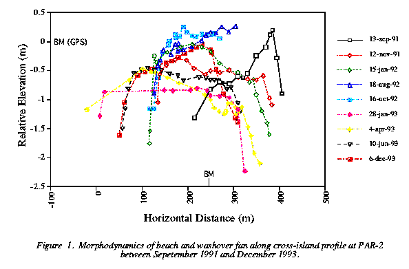 Figure 1. Morphodynamics of beach and
washover fan along cross-island profile at PAR-2 between Sepetember
1991 and December 1993.
Figure 1. Morphodynamics of beach and
washover fan along cross-island profile at PAR-2 between Sepetember
1991 and December 1993.
Figure 2. Topography and vegetation facies
map of PAR-3 in July 1994
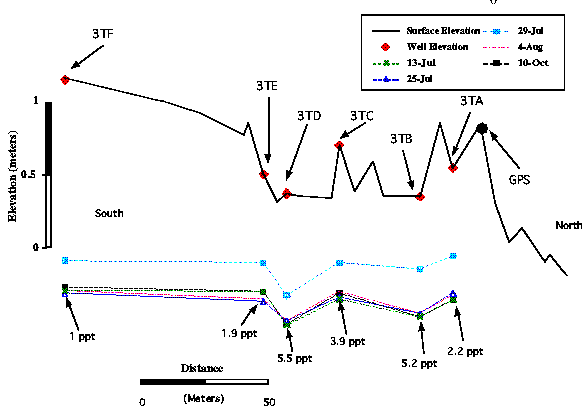 Figure 3. Cross-fan topography, water tables, and average salinity
between May-October 1994 at PAR-3.
Figure 3. Cross-fan topography, water tables, and average salinity
between May-October 1994 at PAR-3.
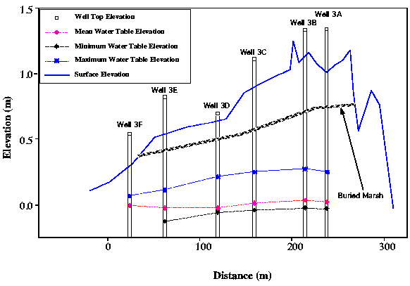 Figure 4. Variation in water table position between May-October 1994 at
PAR-3. Well transect shown is across the mid-fan area parallel to shoreline
strike.
Figure 4. Variation in water table position between May-October 1994 at
PAR-3. Well transect shown is across the mid-fan area parallel to shoreline
strike.
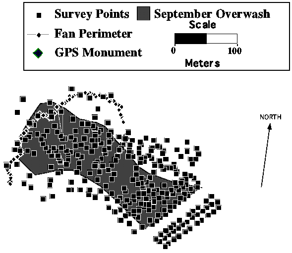 Figure 5. Survey points for PAR-3 showing extent of area affected by
overwash in September 1994 storm. This area received extensive planation of
minor dunes and significant erosion of larger dunes.
Figure 5. Survey points for PAR-3 showing extent of area affected by
overwash in September 1994 storm. This area received extensive planation of
minor dunes and significant erosion of larger dunes.