 Topographic Mapping of Barrier Islands Using GPS Technology |
Charles R. Carlson and Raymond D. Dueser
VCR/LTER
|
|
Topographic Mapping of Barrier Islands Using GPS Technology |
|
Charles R. Carlson and Raymond D. Dueser
VCR/LTER
|

Topographic Mapping of Myrtle Island
of the Virginia Coast Reserve
Utilizing Global Positioning System Static and Kinematic Techniques
Click Photos on either side for the April 1997 flight photos
Charles R. Carlson, Research Site Manager, VCR/LTER
Raymond D. Dueser, Professor and Department Chair, Department of Fisheries and Wildlife, Utah State University |
Abstract
Barrier islands of the Virginia Coast Reserve are noted as highly dynamic and the small mammals which thrive on this 'high-speed real estate' are as dynamic in nature as the islands they inhabit. Oryzomys palustris (marsh rice-rat) is an effective disperser over water and occurs on 21 of the 24 islands whereas Peromyscus leucopus (white-footed mouse) is less effective and occurs on only 4 islands (Dueser, et.al.). During periods of hurricane or storm flooding from rising tides, there is limited habitat available for small mammals which can give rise to migration from island to island or island to mainland causing a dispersal of genes throughout the barrier island ecosystem. In some cases it can lead to an extinction of a species on an island or in other cases introduce a new species to an island. In an effort to determine available habitat during flooding events, barrier island topography and elevation above Mean Sea Level, Global Positioning System technology was employed in the static and kinematic modes to produce three-dimensional mapping of Myrtle Island of the Virginia Coast Reserve.
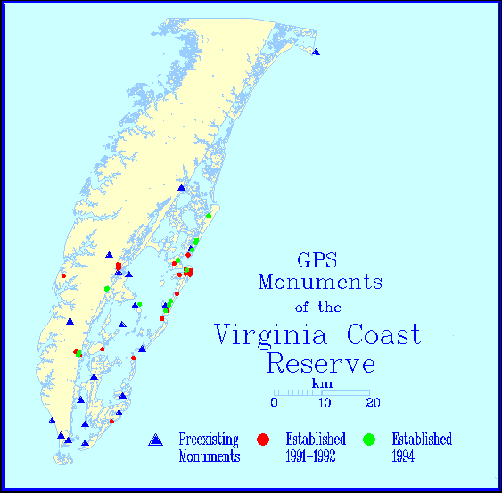
The horizontal and vertical control was established on Myrtle Island utilizing the 1992 VCR/LTER GPS Network where the latitude, longitude and ellipsoid elevation of 45+ benchmarks were established on the millimeter scale. Benchmark GOOD, located on the south end of Ship Shoal Island, was the horizontal and vertical control used for this survey. Five static benchmarks were then created (extending baselines from GOOD to the north end of Myrtle Island) in which there was approximately two hours of data collection on each newly established benchmark; this gave rise to horizontal accuracies on the 1: 400,000 + range where all baselines were less than 700 meters (horizontal accuracy approximately 0.00175 meters and vertical accuracy estimated at 0.0035 meters). Several baselines were on the 100-200 meter length on the horizontal axis which provided sub-millimeter (potential) errors.
 With
the static network established, the kinematic data collection began with
points collected on the 10-meter horizontal axis in and around the VCR/LTER
Small Mammal Grids 24 and 25. Points were also collected
whenever there was a topographic event which best described the three-dimensional
state of the island; areas which provided little topographic change gave
rise to points collected up to 30-50 meters apart on the horizontal axis.
Twelve unique data collections provided 20.526 MB of data in which 864
of the 1200+ kinematic points collected passed the rigid statistical analysis.
The 864 points utilized in the mapping passed the Chi-Square
Test with a 95% confidence level. The 300+ kinematic points failed
due to poor statistics during the final processing using a centimeter-scale
strategy on the vertical axis. The image
to the left displays the distribution of the x, y coordinates;
the north to south distance is approximately 1300 meters and the east to
west distance is approximately 550 meters.
With
the static network established, the kinematic data collection began with
points collected on the 10-meter horizontal axis in and around the VCR/LTER
Small Mammal Grids 24 and 25. Points were also collected
whenever there was a topographic event which best described the three-dimensional
state of the island; areas which provided little topographic change gave
rise to points collected up to 30-50 meters apart on the horizontal axis.
Twelve unique data collections provided 20.526 MB of data in which 864
of the 1200+ kinematic points collected passed the rigid statistical analysis.
The 864 points utilized in the mapping passed the Chi-Square
Test with a 95% confidence level. The 300+ kinematic points failed
due to poor statistics during the final processing using a centimeter-scale
strategy on the vertical axis. The image
to the left displays the distribution of the x, y coordinates;
the north to south distance is approximately 1300 meters and the east to
west distance is approximately 550 meters.
Using Arcview 3.0 (with the Arcview Spatial Analyst) and GPS data collection techniques, Myrtle Island has been captured in its topographic state in August of 1996. The contour mapping is based on a 1 centimeter vertical accuracy range and has provided a unique view of a barrier island . The contour mapping in Arcview is set at 0.1 meters (0.01 cm contour lines are available while using the ArcView Spatial Analyst although images on this scale do not show good representation).
The following images are selected to represent Myrtle Island in its topographic state in August 1996:

Myrtle Island July 1996 Photos (Click Photo)
In April of 1997, it was noted that VCR/LTER Small Mammal Grid 24 had been 'disturbed' by the westward migration of the ocean shoreline (see Fig. 7). The shoreline is now situated through the middle of Grid 24 with trap position 24-5.1 thru 24-5.4 beyond the berm of the beach. An overwash fan has blown thru adjacent to 24-1.1 and it was necessary to abort this grid due to its close proximity to the ocean shoreline. Using the ArcView analytical tools and the x,y coordinates of Grid 24, it was noted that the shoreline has migrated westward approximately 540 meters adjacent to Grid 24 in a period of 8 months.
Future plans are to conduct another topographic survey of Myrtle Island during the 1997 summer field season which will be utilized in the VCR/LTER Small Mammal Project in addition to a barrier island migration study (Kochel, et. al.). Plans include modelling shoreline change, sediment accumulation-surface change, sediment volume change (Stella Model), tidal data (especially during storm tides) in addition to the small mammal studies on Myrtle and Ship Shoal islands. Considering that approximately 540 meters of shoreline has migrated westward which contained high dune ridges (see Fig. 3) up to 5-6 meters above MSL, a substantial amount of sand migration should be documented on a very large-scale process.
Loxterman, J.L., Moncrief, N.D., Dueser, R.D., Carlson, C.R., and Pagels, J.F., 1995. Allozymic Variation in Sympatric, Insular and Mainland Populations of Two Rodents (Oryzomys palustris and Peromyscus leucopus): The Effect of Dispersal Capabilities on Genetic Population Structure.
