| Regionalization at the CWT |
|
Authors: Brian D. Kloeppel
Scientific Basis for Regionalization at the CWT LTER Site
| Regionalization at the CWT |
|
|
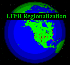
Regionalization research at Coweeta expands our LTER studies beyond the borders of Coweeta Hydrologic Laboratory to encompass the eastern part of the Blue Ridge province, in the southern portion of the Appalachian Highlands (Figure 1). This region is 56,500 km2, includes parts of five states, and is a complex mix of private and public ownership. It was delineated by Braun (1950) as the Southern Appalachian oak-chestnut forest. Although this community type extends further north and west, we are confining our studies to the region that most represents Coweeta’s climate, geology, elevation, and water chemistry. This region is a center for aquatic and terrestrial biodiversity in the United States, with as many tree species as in all of Europe and over thirty endemic fish species in just one of its river basins (Hackey et al. 1992). The regional landscape is changing rapidly because of timber harvesting as well as land clearing and road construction for vacation or retirement homes.
Our goal is to develop a predictive understanding of the social, economic, and environmental factors that drive land cover change in the Southern Appalachians and the ecological consequences of those changes in landscape pattern for regional C cycles and for terrestrial and aquatic biodiversity. We wish to do this with an integrated program that recognizes humans as an integral part of the Southern Appalachian landscape. We combine the long-term perspective of change in the vegetation and in C stores since the Pleistocene with recent changes in land cover and modeling of human decisions regarding land use to understand past and likely future drivers of changes in landscape pattern in the region. We consider the effects of these landscape changes on regional C storage and flux rates and on the biota of a region that is characterized by high biodiversity.
I. Scientific Rationale
II. Regionalization Research
II.A. GIS Spatial Analyses
II.B. Socio-economic Research
II.C. Terrestrial Research
II.C.1. Vegetation Biodiversity
II.C.2. Small Mammal Biodiversity
II.C.3. Historical Vegetation Dynamics
II.C.4. Regional Carbon Cycling
II.D. Aquatic Research
III. References
III.A. Journal Publications
III.B. Theses
III.C. Presentations
IV. Funding Acknowledgments
II. Regionalization Research
II.A. GIS Spatial Analyses
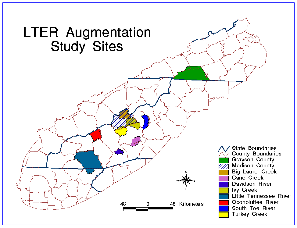
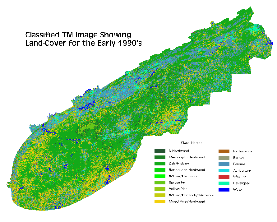
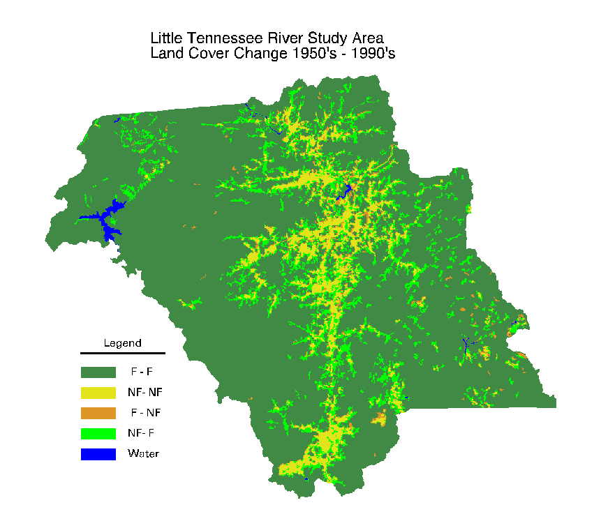
The Coweeta regionalization effort has several foci. First, we have been developing baseline spatial data to support research efforts in a number of our topic areas, i.e. terrestrial, stream, socio-economic, etc. Data have been developed for both a large region encompassing more than 60 counties and three states in the southern Appalachian Mountains, and for a more detailed set of measurements on a subset of typically watershed-based study areas (Figure 1). Data developed for the larger study region include digital elevation, slope, and aspect data, 1970s landcover, 1990s landcover and vegetation data, county population, demographics, and economics from census data, 1:100,000 hydrography, regional soils data, road networks, and political and administrative boundaries (Figure 2). These have also been developed for the detailed study areas, with additional data including detailed current vegetation data, 1950s landcover from interpreted aerial photographs,1:24,000 based hydrography and transportation network, watershed boundaries, control point networks, GPSed biotic sampling locations, and block group population census data (Figure 3). Various synthetic spatial data layers have been produced and maintained to support specific analyses (e.g. landcover or vegetated areas within 100 m of sample streams, indices of terrain convexity, and spatial metrics of forest fragmentation).
II.B. Socio-economic Research
Several socio-economic scientists on our project have been addressing the determinants of land use change in the Southern Appalachians. Previous research has been extended to examine the effects of prices of goods and services as well as locational factors that define costs of various land uses. Over the last year, data collection for this phase of the research was completed. Sixty study sites were identified and 9 plots were defined within each study site. Aerial photos were interpreted to define land uses (forest agriculture, and human- dominated) in 1953, 1963, 1981, and 1994. Additional site data were compiled for each plot, including: slope, elevation, distance to roads, and distance to market. Values of land in agriculture and forestry uses were estimated in index form based on commodity prices in the years examined and the soil type of each plot. Initial analysis of land use changes has used binary choice models to examine the probability of land cover changing from one state to another. These models have been used to examine various hypotheses regarding the influence of variables on the probability of change and the stability of land use choice models between periods. Findings confirm that locational and site variables do have a significant influence on land use change.
Land use values also hold significant influence over certain types of transitions. Tests for stability indicate that while choices related to agriculture and forestry uses have been stable over this long period, choices determining land development have changed considerably. Models are now being extended to allow simultaneous consideration of all land use options and alternative formulations of spatial relationships. These models will be used to complete hypothesis tests for this phase of the regionalization project.
II.C. Terrestrial Research
II.C.1. Vegetation Biodiversity
Our socio-economic studies will help to elucidate the extent and incentives for altered and more extensive land-use in Southern Appalachian ecoystems. The biotic factor most likely to receive increased awareness is the biodiversity of our ecosystems which is extremely high relative to most sites in North America and Europe. Our terrestrial biodiversity studies are investigating the effects of habitat fragmentation and historical land use on the biota of cove forests in the Southern Blue Ridge province. Data collection efforts during the past two years have been devoted to measuring these effects on breeding birds and vascular plant communities. Studies of plant communities have become the richest source of information about land use and fragmentation.
Our studies of the plant communities of cove forests have revealed that the area of a forest patch influences the diversity and composition in its community. Small patches have a larger component of edge species. Edge species are adapted to conditions of high light levels and frequent disturbance, and small patches have more microsites with these conditions than large patches. Smaller patches also have reduced diversity and abundance of forest-interior species. These species generally thrive in moist, shady, undisturbed microsites. The effects of patch size on forest-interior species could produce any, or a combination, of the following factors: (1) small patches have smaller populations and suffer higher probabilities of local extinctions. (2) fragmentation interferes with population dynamics, such as colonization. (3) edge species compete with forest-interior species for limiting resources (e.g. soil nutrients, water, light). This competition reduces the number and diversity of forest-interior species where edge species are more abundant. (4) Finally, smaller patches have been disturbed (e.g. logging, grazing, cultivation) more frequently and more intensely than larger patches. Differences in disturbance history are evident in soil carbon storage. These disturbances may result in habitat degradation and/or local extinctions. Our present field research seeks to determine which of these mechanisms is (are) responsible for the observed pattern and link them to ecosystem process such as soil formation and carbon storage.
We are also conducting simulation studies to investigate the effects of habitat fragmentation on the persistence of species employing different life-history strategies. A spatially explicit model of population dynamics has been created to simulate the persistence of populations in landscapes that vary in the abundance and spatial configuration of habitat. The model interfaces with actual land-cover maps of the study region stored in a GIS. So far, investigations with this model have revealed that, given the same intrinsic rate of growth, life-histories strategies that maximize year-to-year survivorship at the expense of fecundity and dispersal are better at persisting in fragmented landscapes. Annual plants with limited vagility were especially vulnerable to local and landscape-wide extinction. This result is consistent with the composition of herb communities in forest coves. These communities are dominated by species that are long-lived and have the capabilities of vegetative reproduction.
II.C.2. Small Mammal Biodiversity
We have also made great progress on the understanding of small mammal communities in and around the Coweeta Basin. There are currently several projects underway each with a short synopsis below.
A. Role of riparian zones in structuring small mammal communities:
Twelve riparian zone study sites (3 each seeps, first order, second order, and 3 third order streams) representative of a range of elevational and vegetational community types were compared with adjacent non riparian habitats. Riparian zones exhibit higher species richness and population densities compared to controls.
B. Southern Appalachian regional perspective:
We have examined patterns of species richness and diversity of small mammals across various land type associations, vegetational communities, and elevations throughout the southern Blue Ridge and upper Piedmont transition zone. Correlations drawn between land types, vegetational communities, and elevations permit predictive models to account for distribution and relative abundance of small mammals in a regional perspective.
C. Surveys for rare taxa:
The water shrew, Sorex palustris, is among the rarest mammals in the southern Appalachians. There are less than a dozen records in the southern Appalachians south of Virginia. We found it to be abundant in high elevation first order streams, so much so that we have initiated an analysis of its distribution based on correlations to habitat features related to physical and biological characteristics of the stream systems in which it occurs. Our study will have significant implications regarding management. Our regional surveys have added significant information on other small mammals generally regarded as rare in the region (Sorex hoyi, Cryptotis parva and Napaeozapus insignis). We have published or submitted several papers relating to these species.
II.C.3. Historical Vegetation Dynamics
In addition to major projects addressing biodiversity in terrestrial vegetation and small mammal populations, we have also undertaken a large study to analyze how climate, vegetation, and fire have changed since the Pleistocene. Of several dozen sites visited in the southern Appalachians, seventeen sites have been selected for analysis. Sediment coring, dating, pollen, and charcoal analyses of these sites are in progress or planned for 1997. The remaining sites will be cored during the winter of 1996-97. Samples are being analyzed for radiocarbon dating, Pb-210 analysis, and pollen analysis. Charcoal analysis is largely complete for eight sites, but we await dates to determine fluxes. Data are too preliminary to observe patterns. We have found presettlement charcoal levels to be high at all sites, so it is clear that fire was a part of the presettlement landscape, even in these mountainous sites.
II.C.4. Regional Carbon Cycling
Building upon the historic perspective generated by sediment sampling as well as taking advantage of the spatial analysis of landcover in the Southern Appalachians, we are developing a regional carbon model. During the past 18 months we have conducted a number of field sampling, spatial data collection, and model development activities to support estimation and modeling of regional carbon pools and fluxes. We have sampled soil carbon, nitrogen, root biomass, and soil CO2 flux at a network of spatially-referenced sites within the region, and have been developing relationships between landscape metrics and driving variables (e.g. predicting soil carbon and root biomass from measured landcover, terrain shape, and elevation). Respiration-temperature response curves have been developed for the foliage of most canopy tree species in the region. In addition, tree woody respiration has been quantified and species-specific temperature response curves have been generated for all seasons. Regional meteorological data have been organized and integrated with the Coweeta measurement sets, and we are currently evaluating alternative methods of modeling local to regional climatic driving variables. All these data are being integrated into a regional carbon cycling model, which provides spatially-explicit prediction of whole system and component carbon fluxes and pools, including photosynthesis, plant and soil respiration, carbon storage and allocation by tissue type, and leaf biomass, litterfall, and detrital production.
II.D. Aquatic Research
In addition to our interest in terrestrial research, several scientists have also begun a rigorous investigation of the relationship between historical land-use change and invertebrate and fish biodiversity in streams of the Blue Ridge Province. Invertebrates and fish are being sampled in 36 streams in the Little Tennessee River and French Broad River drainage basins. Streams were selected on the basis of current land-use and size. Twelve small (approximately 3rd order) and twelve large streams (approximately 5-6th order) draining forested, pasture-land, or "urbanized" land were selected. Initial site selections were made from 7.5 min topographic maps. We then ground proofed the sites for current land-use and selected streams within groups (e.g. small-forested) that were of equivalent size and flow, general water quality (pH, conductivity, hardness), riparian cover, riffle-pool development, and substrate type. Sampling was stratified by riffle and depositional zones in the study reaches.
Invertebrate sample processing is still under way; initial analyses from the Little Tennessee basin for forested vs. pasture streams indicate the following: 1) no significant differences in invertebrate density between land-use type or stream size; 2) larger pasture streams appear to have fewer taxa; 3) there appear to be no significant differences in diversity indices but there are fewer sensitive species, e.g., Plecoptera, in pasture streams.
Current findings in fish biodiversity indicate that: 1) fish diversity is slightly greater in the Little Tennessee than in the French Broad River basin; the lower diversity in the French Broad primarily results from reduced species numbers in small streams. 2) Agricultural streams have higher diversity than forested streams, which probably results from the effects of introduced predators (brown trout, rainbow trout), which are limited to forested streams. 3) In both rivers, agricultural sites have more and finer sediments; increased sediments correlate with fish distribution, favoring species with breeding habits that overcome sediment deposition (large guarding males that keep spawning sites clean). 4) Disturbance, in the form of patches of non-forested land converted to agriculture, affects fish assemblages and stream habitats.
Fish density decreases in direct proportion to patch size. A threshold effect is apparent in terms of assemblage composition, with streams downstream from non-forested patches longer than about 1 km showing lower numbers of benthic fishes (darters, sculpins) and larger numbers of water column and pool dwellers (minnows, sunfishes). These shifts in assemblage composition could result from habitat changes associated with increasing patch size. As nonforested patch size increases, moderate and large pools increase in number, whereas shallow pools decrease and riffles and runs become filled with sediments.
The overall plan for the stream work is to integrate invertebrate and fish data to produce a picture of the present state of biodiversity in streams of the two basins. This effort will include a rich historical and contemporary fish and invertebrate data base from the area. We will then use quantitative land-use data (generated from the concurrent GIS effort in the overall project) to examine land-use change over the period of record and attempt to correlate such changes with biodiversity data. We anticipate this integrative effort will help to clarify our view of the long-term trends of biodiversity in streams of the region.
III.A. Journal Publications
During this early stage of our regional research, most projects are in a heavy data collection phase. Please find below a subset of those publications underway that are currently in the submitted and preparation stages.
Harding, J.S. and E.F. Benfield 199_. Land-use influences on the life history of an Appalachian mayfly. Canadian Journal of Fish and Aquatic Science 00: 000-000 (submitted 30 Aug 1996).
Bolstad, P.V., W.T. Swank, and J.M. Vose. 199_. Responses of Southern Appalachian Overstory Vegetation to Terrain and Elevation: Linear Models, Geostatistics, and Typic Diagrams. Journal of Vegetation Science 00: 000-000 (submitted).
Bolstad, P.V., F.C. Collins, J.M. Vose, and L.W. Swift. 199_. Scaling Canopy Micrometeorology from Stand to Regions: an Evaluation in the Southern Appalachains (in preparation).
Bolstad, P.V. and J.M. Vose. 199_. Climatic Controls and Component Canopy Processes Across an Elevational Gradient in the Southern Appalachians (in preparation).
III.B. Theses
Bennett, Barbara, M.S. candidate (Virginia Tech). Comparison of invertebrate diversity in pasture streams with forested headwaters and pasture streams that are cleared to the headwaters.
Chowdury, Rinku Roy, M.S. Thesis (University of Georgia). Socioeconomic and locational factors influencing land use change in Macon County, North Carolina.
Collins, Fred C., Ph.D. Thesis (University of Minnesota). A Comparison of Spatial Interpolation Techniques in Temperature Estimation.
Jones, E.B.D. III, Ph.D. candidate (University of Georgia). Land use effects on fishes in the Little Tennessee and French Broad River basins.
McTammany, Matthew, M.S. candidate (Virginia Tech). Comparison of stream invertebrates along gradient a of stream corridor urbanization.
Wagner, Paul, Ph.D. candidate (Virginia Tech). Comparison of aquatic insect biodiversity in old growth forest streams with streams in 80 year old regrowth forests.
Feldkirchner, Drew (REU Student 1996 - University of Wisconsin - Madison). Tree stem respiration dynamics across a Southern Appalachian chronosequence.
Harper, Josh (REU Student 1996 - University of Georgia). Land use, patch size, and fish assemblages in the Little Tennessee River drainage.
III.C. Presentations
Approximately fifteen presentations of Coweeta regional research were given at national and local meetings in 1996. Please find below a subset of those presentations.
Harding, J. S. & E. F. Benfield. 1996. Temporal land-use changes and their influence on benthic invertebrate diversity in the southern Appalachian streams. 44th Annual Meeting of the North American Benthological Society, Kalispell, MT June 3-8, 1996.
Harper, J., D. Jones, and G. Helfman. 1996. Land use, patch size, and fish assemblages in the Little Tennessee River drainage. 7th Ann S. Appalachian Man and the Biosphere Conference, Gatlinburg, TN, Nov. 1996
Helfman, G.S. and D. Jones. 1996. Land use and fish biodiversity in southern Appalachian rivers. Ann Meeting, Amer Soc Ichthyol and Herpetol. New Orleans, June 1996.
Helfman, G.S., D. Jones, J. Meyer, and M. Paul. 1996. Land use and fish biodiversity in southern Appalachian rivers. 7th Ann S. Appalachian Man and theBiosphere Conference, Gatlinburg, TN, Nov. 1996
Helfman, G. S. , J. L. Meyer, J. H. Harding, E. F. Benfield, E. B. Jones, M. J. Paul and H. Reed. 1995. Land-use and aquatic biodiversity in the French Broad and Little Tennessee River basins. 6th Annual Southern Appalachian Man in the Biosphere Conference, Knoxville, TN Nov 14-16, 1995.
Jones, D., J. Harper, M. Paul, J. Meyer, and G. Helfman. 1996. The effects of land use on stream habitats in the Little Tennessee and French Broad River drainages. 7th Ann S. Appalachian Man and the Biosphere Conference, Gatlinburg, TN, Nov. 1996
Kloeppel, B.D., S.E. Crowley, W.H. Burch, J.M. Vose, and P.V. Bolstad. 1996. Quantification of tree stem respiration dynamics between slope positions and along an eastern hardwood chronosequence in western North Carolina, USA. 1996 Annual Meeting of the Ecological Society of America. Providence, RI 10-14 August 1996.
The major source of funding for the Coweeta regionalization effort is the augmentation of the Coweeta LTER Grant from the National Science Foundation. Additional funding has also been obtained by site investigators from the USDA Forest Service, from related grants from the National Science Foundation, and from the US Man and the Biosphere Project for the Little Tennessee River Basin project.