Human settlement in the Front Range has altered (and will continue to alter) the structure and perhaps the functioning of local ecosystems and their interactions. Native Americans and later populations have affected front range systems in terms of fire frequency and herbivory. Fire suppression, concentration of once wide-spread grazing, and urban development are principal components of current land management; much of this operating across the full elevational gradient. Hot spots of human activity will disproportionately affect biogeochemical and hydrological processes, potentially translating to large-scale alteration of regional systems through atmospheric and hydrologic transport processes. Moreover, predicted global warming may have a unique regional expression in the Front Range through a decoupling of the lower elevation plains from high elevation alpine (suggested by short-term data). A cooling of the alpine with increased persistence of snow cover and warmer plains with altered precipitation regimes would extend an already broad temperature and precipitation gradient in the Front Range. Potential climate change coupled with rapid and diverse landuse change confounds our understanding of local ecosystem dynamics and response to global change.
Our regional approach focuses on 1) linking existing research sites to test for generality and pattern in current biogeochemical processes under study at two or more sites in the Front Range region, 2) development of a paleoecological program to provide a retrospective analysis of past regional change in the Front Range, and to establish the generality of current climatic and biotic trends observed in this region, 3) development of a remote sensing and GIS program to assemble spatial data and conduct analyses of patterns observed over the region, and finally 4) to initiate the beginnings of a collaboration of natural and social scientists to establish the consequences of anthropogenic changes occurring in our region.
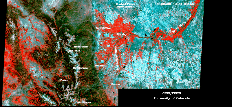
Central to our regional approach are several research sites and programs within the Front Range (See Figure 1). The Niwot Ridge/Green Lakes and Central Plains Experimental Range LTER sites represent the elevational extremes of the Front Range gradient. A second high elevation site exists at the Mt. Evans Field Station of the University of Denver. Montaine sites include: (1) the Loch Vale Watershed, located against the Continental Divide in Rocky Mountain National Park, under study by the NPS and USGS; (2) the USFS Fraser Experimental Forest on the west slope of the Colorado Rockies; and (3) the USFS Glacier Lakes Ecosystem Experiments Site in the Snowy Range due west of Laramie, Wyoming. Protected regions of tall, mixed and shortgrass prairie surround the city of Boulder and are administered by Boulder's Open Space Program. The entire South Platte River Basin is under study by NAQUA and the South Platte Hydrologic Programs. We propose to network, supplement, and synthesize data bases obtained at these research sites. An extensive library of satellite imagery will be assembled for current and retrospective analysis of Front Range climate- landuse-ecosystem interactions.