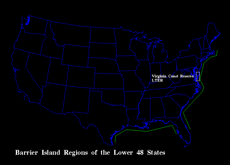
Our ecosystem and landscape studies at the Virginia Coast Reserve, including our core area and experimental studies, apply in a general sense to the barrier island and lagoon systems that form the coastal margin from Cape Cod Massachusetts to Cape Canaveral, Florida on the Atlantic Coast, from Tampa, Florida to Brownsville, Texas on the Gulf Coast and along the margin of much of Alaska's North Slope coastal zone (see VCR Figure 1). These systems are on the trailing edges of continental plates which constitute the coastal plain and extend beyond the current shorelines as the continental shelf. Each of these coastal segments was terrestrial uplands 18,000 years ago but are now the flooded landscapes of the current high sea level stand. The barrier islands, lagoons and marshes of North America are the biome equivalent represented by VCR.
The dynamics of all these coastal systems depend on the relative vertical positions of the land, sea, and fresh-water table and the disturbances in these surfaces. Each of these barrier island coasts occurs within the zone of migratory coastal storms and these landscapes depend on the sediment moving power of these storms. The coastal-marine biota vary from climate zone to climate zone and include the Virginian, Carolinian, Floridian, Caribbean and Arctic coastal-marine biogeographic provinces. VCR scientists have conducted studies on each of these coasts over the past three decades.
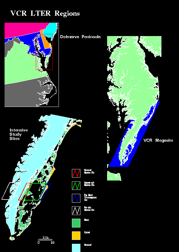
The region surrounding the VCR within which the relative vertical positions of the land, sea, and fresh-water table exhibit a significant degree of spatial continuity and thus subject to systematic regional study is the Delmarva Peninsula and includes the eastern portion of the Chesapeake Bay and the adjacent continental shelf between Cape Henlopen at the entrance to Delaware Bay and Cape Charles at the entrance to the Chesapeake Bay. Within this study region, the level of the land is variable due to organic and sedimentary depositions and to the horizontal transport of sand by waves, tides, currents and winds. The level of the sea is variable due to long-term sea level rise, tidal forcing and storms. The level of the fresh-water table varies with rainfall input, evapotranspiration losses, and human consumptive water uses. Each of these free surfaces are in part controlled by living organisms.
Recorded sea level variations of the waters of the Delmarva Peninsula exhibit an spatial pattern with maximum rates of sea level rise centered on southern section of the Peninsula the VCR LTER site. The Peninsula is a stream, tidal creek and river dissected coastal plain of less than 1 degree slope. On the ocean side of the Peninsula there is a 250 km long sequence barrier islands, lagoons, and marshes. The Chesapeake Bay side is the highly dissected eastern margins of an ancient Sesquahanna River drainage (see VCR Figure 2). The Delmarva Peninsula is a sedimentary province of two parts: a wide northern section of coarse sands and a narrow southern section of fine grained sands. While we conduct remote sensing, paleoecological and shorezone studies over much of the Delmarva Peninsula, the portion of the Peninsula within which we conduct field studies is restricted to the southern section including the Virginia Coast Reserve of The Nature Conservancy, the National Park Service's Assateague National Seashore, and Chnicotague National Wildlife Refuge, Fisherman's Island National Wildlife refuge of the U. S. Fish and Wildlife Service. Our core area and experimental studies are restricted to the bounds of the Virginia Coast Reserve of The Nature Conservancy and a site on the Chesapeake Bay side of the peninsula. This hierarchy of site to regional research areas is illustrated in accompanying image of the Delmarva Peninsula.