 |
Regional Measurement of Terrestrial Vegetation Characteristics in Southwestern Michigan |
| Stuart H. Gage,
G. Philip Robertson, Katherine Gross, and Manuel Colunga |
The row-crop agricultural systems, which are the focus of studies at the KBS LTER, are typical of the cropping system grown in the North Central Region of the United States which includes 12 states (OH,MI, IN, IL, IA, WI, MN, ND, SD, NE, KS, MO), commonly referred to as the "Corn Belt". The temporal dynamics of LAI and NPP across this region is significant due to the complexity of ecosystems represented in this region.
The overall objective is to determine, at a regional scale,
terrestrial vegetation characteristics of the KBS landscape that
will allow: 1) create and provide LAI and NPP information and
model inputs from KBS to MODLAND for regional and global
ecosystems analyses; and 2) participate in intersite LAI and NPP
analysis with other sites in the LTER network.
The specific objectives of this work will be to: a) develop a
land use classification of the KBS LTER region; b) determine the
leaf area index (LAI) for different community types in the KBS
LTER region; c) relate LAI to above ground net primary production
(ANPP); and d) develop a methodology to scale up values of LAI
and ANPP from ground based field observations to the region.
Land use maps of the Kellogg Biological Station are available
in the state plane coordinate system. We are in the process of
georeferencing the KBS LTER area, which is an area of 20x20 km
that includes KBS, the Kellogg Forest, and the Lux Arbor Reserve.
GPS technology is operational at KBS. A 10 x 10 km grid has been
selected for the study site associated with this proposed project
that includes KBS, Kellogg Forest and a major portion of the Gull
lake and Agusta Creek Watersheds. Land use will be classified
based on a Landsat TM 30m scene from August, 1991 and 1993.
The KBS digital vegetation map comprises 40 different vegetation
classes. This information will be reclassified to suit the
MODLAND classification system and will be used as a baseline to
characterize the vegetation of the larger region surrounding the
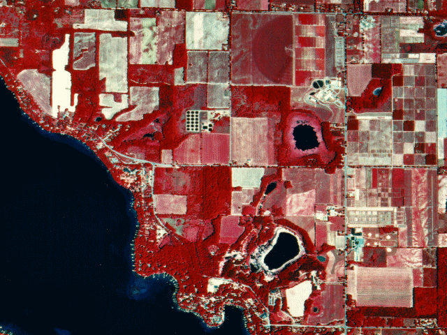
LTER study site. A panchromatic SPOT image shows the approximate
location of the 10 x 10 km grid where intensive LAI and NPP
samples will be collected (Fig 1). The vegetation community types
that will be distinguished include: native vegetation
(succession, deciduous, conifer) and agricultural fields
(alfalfa, corn, wheat,soybean). Other features such as water
(lakes, streams) and urban suburban areas will be included as
well.
The study area will encompass a grid of 10 x 10 km, which each
cell of 1 km2. To determine LAI and ANPP, we will collapse
vegetation into six MODLAND classes. A set of 100 one ha plots
will be sampled to characterize regional vegetation. Of this set,
67 plots are already defined and are used for LTER research.
Those plots comprise the following habitats: 1) annual broadleaf
(soybean), 2) grass (corn, wheat), 3) perennial broadleaf
(alfalfa), 4) perennial deciduous broadleaf, 5) perennial
evergreen needleleaf, and 6) mixed community (succesional
vegetation). The 33 additional plots will be selected to
characterize conifer and deciduous habitats as well as
agricultural crops not included in the LTER rotation scheme.
Sampling on the 100 plot array will provide estimates of LAI and
ANPP for the vegetation types.
Because one of the dominant elements in the KBS LTER landscape is
row crop agriculture which changes substantially in LAI and NPP
over time, it will be necessary to estimate LAI and ANPP
throughout the growing season. Measurement of ANPP and LAI in May
and July will provide information of ANPP variability that will
occur due to change in crop growth and development.
Samples of LAI and ANPP will be measured within each of the 100
plots in the study area. LAI and ANPP estimations per class will
be extrapolated to the region using GIS analyses. The final map
of LAI and ANPP for the KBS LTER region will be developed
according to our classification scheme (eight classes). Since the
LTER/EOS proposal requires that six classes be developed (Running
et al., 1993), LAI and ANPP maps will be produced that correspond
to that classification. All of the maps produced will have a
resolution of 25m (Thematic Mapper). To provide a single value
per km2, an average of the pixels within each 1 km2 cell will be
computed using GIS.
Examples

KBS personnel have been involved in accumulating digital
resources as one means of characterizing the landscape within the
region. A portion of this effort has included detailed vegetation
mapping to characterize the vegetation within the confines of the
Biological Station (1200 acres). Similar mapping has been
conducted at the Kellogg Forest (600 acres) which will serve as a
valuable site for determining LAI and NPP of forests in the
region because of the varied stands planted and the rich
inventory of available data. The Lux Arbor Reserve (1200 acres),
recently added to the KBS complex, comprises a mix of
agricultural fields, uncultivated land, wetlands, unmanaged and
planted coniferous stands. This reserve is currently being mapped
and provides an additional site for LAI and NPP measurements.
This project is part of a multisite project made in collaboration between the LTER network and NASA, to validate local information on landcoverm leaf area index, and primary productivity.
Top | KBS Regionalzation | KBS LTER home page | The LTER network
For information contact: gages@pilot.msu.edu
Document author(s): Stuart Gage
E-Mail: gages@pilot.msu.edu
Revised: December 09, 1996
URL: http://www.ent.msu.edu/esal/lter_region